People ask this question wrong. The question is not which satellite is best. The question is which satellite fits your commodity, your terrain, your coverage needs, and your tolerance for waiting. Sometimes Sentinel-2 is the right answer. Sometimes ASTER. Sometimes you need EMIT or the target is invisible. This article walks through when each one wins.
The short version
If you are just screening an unfamiliar area for the first time, use Sentinel-2. Global coverage, 5-day revisit, free. For 80% of greenfield exploration that is the right starting point.
If your target is high-sulphidation epithermal or Carlin-style gold, or a porphyry copper with argillic alteration, add ASTER. The SWIR bands at 2.2-2.4 µm do things Sentinel-2 cannot.
If your target is lithium pegmatite or rare earth elements, skip the other two and go straight to EMIT. Sentinel-2 and ASTER are not going to find it.
Sentinel-2: the default
ESA's Sentinel-2 constellation is where you start. Two satellites, 13 bands from visible through shortwave infrared, 10-20 metre spatial resolution, and a 5-day revisit globally. The atmospheric correction is done for you in the L2A product. Data delivery is within hours of acquisition.
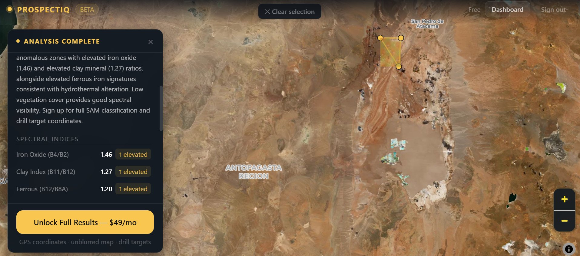
For mineral detection it covers the essentials: iron oxide through B04/B02, clay minerals through B11/B12, ferrous iron through B12/B8A, and vegetation stress through B11/B08. In arid environments where bedrock is exposed, this is often enough to generate a credible target list.
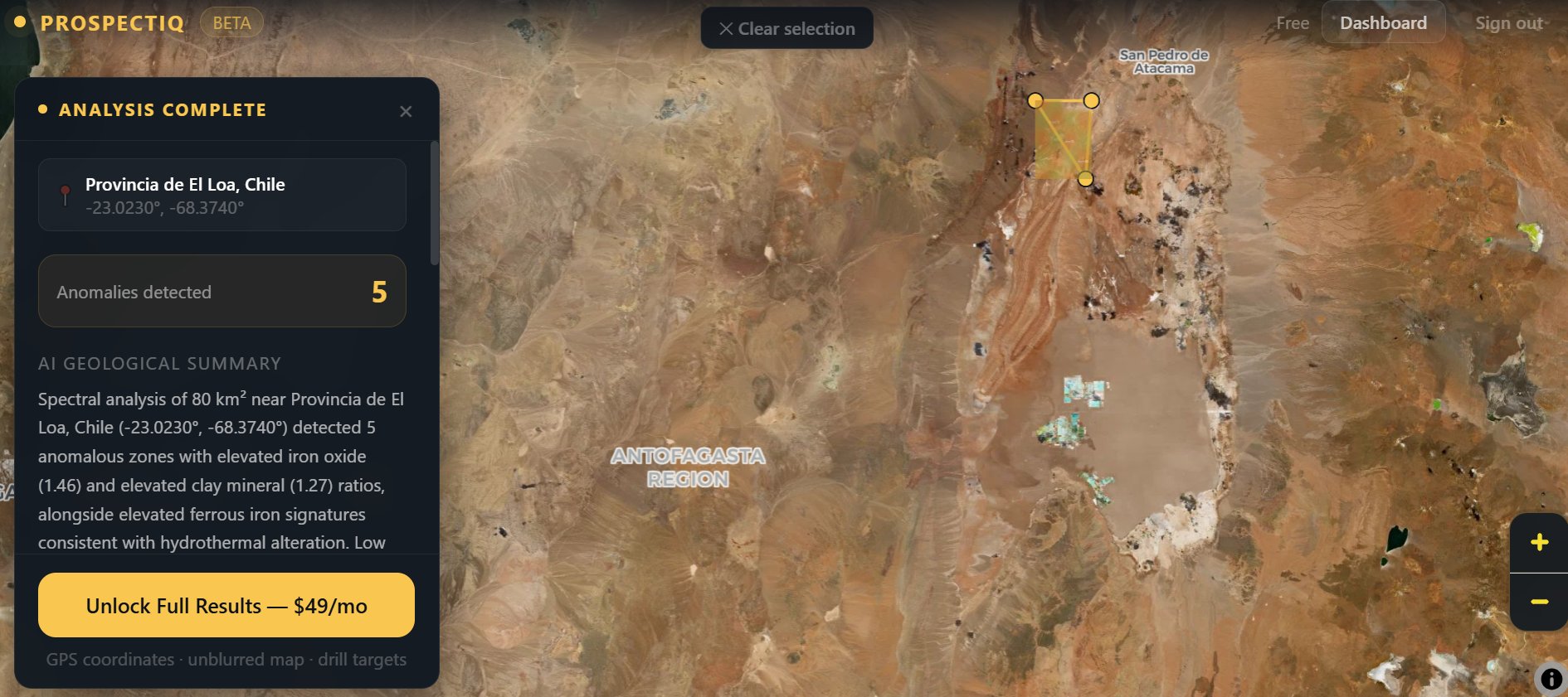
The limitation is spectral resolution. Sentinel-2's SWIR is sampled at only two wide bands (B11 at 1.6 µm and B12 at 2.2 µm). That is enough to know clay alteration is present. It is not enough to tell you which clay. Kaolinite, montmorillonite, and illite all register as "elevated clay" on Sentinel-2, even though their geological meanings are different. For commodities where that distinction matters, you need ASTER or hyperspectral.
ASTER: the SWIR specialist
ASTER has been flying on NASA's Terra satellite since 1999. Old technology by satellite standards, but its SWIR design is still better suited for mineral mapping than anything Sentinel-2 offers. ASTER samples the SWIR with six narrow bands between 1.6 and 2.43 µm, where Sentinel-2 has two.
The extra bands resolve mineral absorption features that Sentinel-2 blends into a single response. Kaolinite has a diagnostic double absorption at 2.165 and 2.207 µm. Sentinel-2's B12 averages over both and reports a single value. ASTER's Band 5 (2.145-2.185 µm) and Band 6 (2.185-2.225 µm) resolve them separately.
The big one is Band 9 at 2.36-2.43 µm. This catches the K-OH absorption in alunite and jarosite. Those two minerals are key pathfinders for high-sulphidation epithermal gold (Yanacocha, Pascua-Lama, Pueblo Viejo) and porphyry copper acid-sulphate systems. Sentinel-2 has no band in that wavelength range. If you are exploring in the Andes, the Pacific Rim, or anywhere with epithermal potential, ASTER is not optional.
ASTER's SWIR resolution is 30 m per pixel, versus 20 m on Sentinel-2. That sounds worse but the narrower spectral bands more than compensate for the wider pixels. In practice, ASTER is better for deposit-scale SWIR mineral mapping.
The catch: new ASTER acquisitions have been limited since 2024 because of instrument issues. The archive going back to 2000 is fine for most exploration work because bedrock geology does not change in 25 years. But if you need a recent clear-sky acquisition over a specific target, that is no longer guaranteed.
EMIT: the hyperspectral option
EMIT is NASA's hyperspectral imaging spectrometer mounted on the International Space Station since July 2022. It measures 285 spectral bands continuously from 380 to 2,500 nm at 60 metre resolution. That is an order of magnitude more spectral detail than Sentinel-2 or ASTER provide.
For most commodities this level of detail is overkill. Sentinel-2 will tell you iron oxide alteration is present. ASTER will tell you whether it is jarosite or goethite. EMIT will tell you the exact mineral mix including trace species you did not know were there. That level of precision is valuable but rarely necessary for target generation.
For two commodities EMIT is the only free option that actually works.
Lithium pegmatites contain spodumene, which has diagnostic absorption features at 1,200 nm, 1,480 nm, 2,206 nm, and 2,308 nm. Sentinel-2 captures one of those (near B08A). ASTER catches two of the SWIR features with low confidence. EMIT resolves all four clearly. If you are doing greenfield lithium exploration and you need spectral evidence, EMIT is required.
Rare earth elements are the second case. REE minerals like monazite and bastnäsite have diagnostic absorption features in the 500-1,300 nm range that Sentinel-2 simply does not have bands for. EMIT samples this region continuously. For REE prospecting, it is the only satellite option.
The catch with EMIT is coverage. It orbits from the ISS at 51.6° inclination, which covers roughly 60°N to 60°S. Acquisition prioritises arid and semi-arid regions because the mission's primary purpose is mapping dust source areas. If your target is in tropical Africa or the Andes or Australia, coverage is good. Northern Canada, Scandinavia, Russia — EMIT does not go there.
The vegetation problem
Spectral satellite data only works where the bedrock reaches the surface. Everywhere else, you are looking at soil, vegetation, water, or cloud. The wetter and more vegetated your target, the less useful any of these satellites become.
The Democratic Republic of Congo hosts some of the world's best copper and cobalt deposits, but satellite exploration there is genuinely hard. Vegetation cover ranges from 40% in open savanna to 90%+ in the rainforests of the western part of the country. NDVI above 0.6 attenuates the SWIR mineral signal enough that SAM classification becomes unreliable. You can still detect broad alteration halos through the vegetation stress response (plants growing over mineral-rich soils are often stressed in detectable ways), but fine mineral discrimination requires either drill samples, geochemistry, or hyperspectral airborne surveys.
None of Sentinel-2, ASTER, or EMIT solves the dense vegetation problem. They just handle it with varying degrees of grace. EMIT's hyperspectral detail helps most because subtle vegetation stress features are easier to detect in continuous spectra. Sentinel-2 handles it worst because its two SWIR bands have no room for nuance.
Worked example: Witwatersrand Basin, South Africa
The Witwatersrand is the largest gold district in history. Over 1.5 billion ounces of gold produced since the 1880s, and still producing. The geology is a sequence of Archean auriferous conglomerates (reefs) buried under younger sediments and covered in agriculture and urban development.
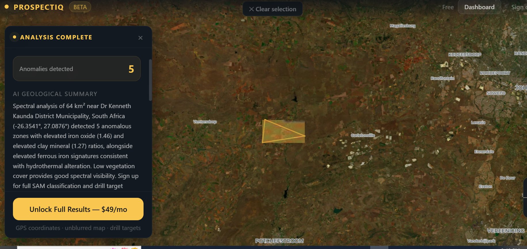
This is a case where Sentinel-2 alone handles the job. The alteration signatures the pipeline needs — iron oxide gossans and clay halos from the weathered reef outcrops — are easily resolved by the two SWIR bands. ASTER would add confidence by separating the specific clay minerals (kaolinite vs sericite tells you something about the depth of the weathering profile), but for a first-pass screening Sentinel-2 gives you a credible target list within the 60-second analysis window.
What would EMIT add? Not much in this setting. The Witwatersrand is not about lithium or REEs. The hyperspectral detail would let you map weathering profiles more precisely, which has academic value but does not change the drill target list. This is the default exploration workflow — Sentinel-2 does 80% of the work, ASTER closes gaps for specific deposit types, EMIT is for niche commodities.
Head-to-head comparison
| Sentinel-2 | ASTER | EMIT | |
|---|---|---|---|
| Bands | 13 | 14 | 285 |
| Spatial resolution | 10-20 m | 15-90 m | 60 m |
| SWIR bands | 2 (wide) | 6 (narrow) | ~140 (continuous) |
| Revisit | 5 days | 16 days (archive) | Variable (ISS) |
| Coverage | Global | Global (archive) | 60°N to 60°S |
| Strength | Fast, frequent, global | SWIR mineral discrimination | Hyperspectral detail |
| Best for | Screening, iron oxide, general alteration | Epithermal gold, porphyry Cu argillic | Lithium, REEs |
Picking by commodity
For orogenic gold and iron oxide exploration (greenstone belts, Witwatersrand-style, BIF targets): Sentinel-2 is enough. The weathered iron oxide signatures are strong and easily resolved by two SWIR bands.
For high-sulphidation epithermal gold and porphyry copper with alunite/jarosite: add ASTER. Sentinel-2 will show you the iron oxide signal but cannot confirm the K-OH alteration minerals that define these deposit types.
For Carlin-style gold: Sentinel-2 plus ASTER plus Landsat-9. Carlin deposits need alteration mapping (ASTER), decarbonation mapping (TIR from Landsat-9), and regional screening (Sentinel-2) combined. No single satellite handles it.
For lithium pegmatites: EMIT or nothing. Sentinel-2 cannot see spodumene reliably. ASTER has bands near the right wavelengths but not enough spectral detail. EMIT resolves the diagnostic features at 1,480 nm and 2,206 nm cleanly.
For rare earth elements: EMIT only. The diagnostic features are below 1,300 nm where the other satellites have no relevant bands.
For nickel laterite and bauxite: Sentinel-2 alone. Both deposit types produce strong iron oxide and clay signatures that are easily detected with two SWIR bands.
Combining satellites
In practice, the best exploration workflows layer multiple satellites. You start with Sentinel-2 for regional screening because it gives you fresh data on a 5-day cycle. You drop ASTER archive data over the anomalies of interest for SWIR mineral discrimination. You use EMIT if the commodity demands hyperspectral detail and if coverage exists over your target.
ProspectIQ's free and paid tiers use Sentinel-2 as the primary data source because it covers the widest range of commodities and has the most reliable global coverage. ASTER integration for epithermal gold and porphyry copper is a Premium tier feature. EMIT for lithium and REEs will come in a future release.